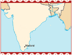
 Madurai is located in south-eastern India, on the banks of river Vaigai. It is one of the 30 districts in Tamil Nadu. Infact, the city serves as the district headquarters of the state. The geographical location of Madurai is 9.91 N 78.1 E. It is located at an altitude of 100.58 meters (330 feet) above sea-level. According to 2001 census it had a population of 922,913. It is 56.01 percent urbanized, with a literacy rate of 78.65 percent. Madurai city acts as the administrative capital of Madurai district.
The male percentage in the city is 51 percent, while female percentage is 49 percent. The district of Madurai has been divided into seven Talukas, namely Madurai (North), Madurai (South), Thirumangalam, Peraiyur, Usilampatti, Vadipatti and Melur. The second-largest city of Tamil Nadu, Madurai stands surrounded by three small prominent hills, called the Annamalai, Pasumalai and Nagamalai, based on their supposed resemblance to an elephant, a cow and a snake respectively.